
About this Project
This project aims serve as a feasibility report regarding the use of UAS technology for purpose of surveys of mussel beds (and similar environments) in UK coastal environments. The primary focus is to maintain accuracy of the survey whilst having the minimum impact on the habitats and their wildlife whilst capitalising on the benefits of Drone Technology. I aim to utilise predominantly off the shelf drone systems and software, so this system can be implemented widely as possible with as little financial burden as possible.
Drone use in the conservation sector is increasing, however there is a minimal impact being made with regard to governmental monitoring instances. This project aims to increase the accuracy of the Inshore Fisheries Conservation Authorities’ datasets, which are used to track and inform harvesting quotas of mussel and cockle beds (and other similar stock types) in the UK’s coastal and inter-tidal habitats.
This will run for the majority of the summer of 2018, with the findings being published on occasion, with final submission to LJMU being made in the latter part of September.
Potentially Interested Parties
- Inshore Fisheries Conservation Authority
- Environment Agency
- Department for Environment Food & Rural Affairs
- Bangor University (Marine Biology Dept.)
- Wirral Country Parks (land carer)
- Wirral Council (landowner)
- Dee Sailing Club (local to the survey site)
- Royal National Lifeboat Institute
- Natural Resources Wales (if necessary)
- Bivalve Mollusc Working Group
- Marine biologists everywhere
…this list is not exhaustive, if you know of others who might be interested in the methodology, the data or any other aspect of this by all means let me know or get them in touch with me.
The problems we’re looking to solve:
- NW-IFCA are expected to oversee 450 miles of coastline with finite resources. This new system could step in to survey a large number of their more challenging to access areas, which in turn will reduce/eliminate risk to life and limb whilst dramatically decreasing costs.
- To access the mussel beds (in particular those described below) there is a lengthy, expensive process involving approximately these steps:
> board vessel at docks (Liverpool)
> wait for high tide
> make way to site at Dee
> position vessel over mussel bed, weigh anchor
> wait for tide to go out
> land boat/beach boat on the beds
> carry out limited area survey
> board vessel
> wait for tide to come in
> return to portThis process could take up to 18 hours in some instances, longer if sites are further from port.
In principle, when this project is complete, I will show how this information can be obtained whilst: Reducing costs; Reducing/eliminating the environmental impact; Increasing data availability and Increasing accuracy.
Overarching project aims:
- Determine optimal methodology for UAV surveys for cockle/mussel beds in inter-tidal zones in UK estuaries in relation to:
> aircraft altitude(s),
> aircraft speed over ground,
> optimal image overlaps. - Design a measurement system to increase accuracy of survey data using a secondary UAV.
- Objectively appraise the systems’ efficacy compared to traditional methods [with respect to financial and time-based constraints].
- Provide an evaluation and recommendation of suitability for off-the-shelf systems that are preferable for this type of application.
- Compare predicted weights of catches based on UAV data with those recorded by the Inshore Fisheries Conservation Authority.
- Demonstrate awareness of prior work through a literature review and apply relevant project management relevant to stakeholders in this tightly regulated operating environment.
Main site of interest in this study: Northern Dee Estuary, offshore of Thurstaston Country Park.
The mussel beds I intend to survey are offshore of Thurstaston Country Park between 600 and 800m. I would need to secure a take off and landing zone a little way offshore away from the cliffs in order to remain within the legal range whilst the drone(s) are in flight (Max 500m).
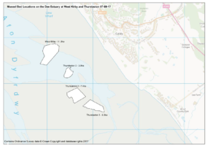
The map above is a snapshot from page 7 of this IFCA document (PDF link to NW-IFCA Site) that has lots more information on the sites I’m focusing on. I intend to survey all four if I can, and if not, just one (the northern, 11ha site as this will provide the largest dataset). In theory a max speed survey (~15m/s) of 11ha would take 15 minutes.
Proposed Data Capture Method
(as of 12/06/2018)
The aim is to survey the sites multiple times over late June, July and August. This should allow a collation of change-over-time data. This is however subject to obtaining relevant permissions from the authorities to fly a UAV in this airspace.
Natural England, Wirral Council and Wirral Country Parks, and others will need to consent to this activity, and the flights will be undertaken using the licenses and insurance provided by Drone Factor Ltd. Flight planning documentation will be on record, along with any other pertinent documents regarding permission to fly in this area. The use of the Drone Factor PfCO will expedite the necessary flights of the UAV’s, whilst also documenting a ‘normal’ course of action where paperwork and negotiation is involved. There will be no financial gain from this study for Drone Factor Ltd.
Methodology for data acquisition at present, which is in it’s basic form below. For illustrative purposes, the map below (not scaled) outlines the data collection method basics.
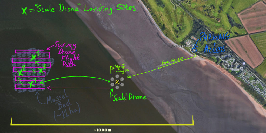
The premise is that two UAV’s are used to conduct the survey.
The primary UAV flies in a ‘lawnmower’ pattern over the site, capturing nadir images which can be processed in Pix4D to create 3D models, point clouds and measured in other ways to provide the change over time data.
A secondary UAV would be positioned (landed, stationary) on the site to provide scaling and pseudo ground control points, enabling increased accuracy of the final digital surface models created in post processing. The secondary UAV will be positioned in four or more locations during the survey. The primary UAV will be paused whilst the 2nd drone is re-positioned to serve as scale reference in other locations.
The DJI F550 platform is prime for modification to serve as a mobile scale. Standard F550 landing legs are too small and thin to land reliably on the beach without sinking. To mitigate the issues that might arise due to the legs being stuck into the mud on landing, weight spreading feet will need to be attached. A preliminary design has been created in Solidworks.
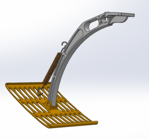
A spring will encourage even landing, and will stop the turbulence from the propellers from damaging the feet whilst in flight. The holes in the foot reduce weight whilst also allowing the water/sand to drop off.
Flight Condition Considerations
These are basic flight considerations. Complete flight planning will be undertaken in due course, relating to low tides (when the beds are exposed) and when there is sufficient natural light.
Present paradigms for UAV survey flight say the optimal conditions for a photogrammetry survey are: midday sun; little to no wind and minimal cloud cover. Exact weather flight conditions might need to be a little flexible with regard to hitting the best weather for the survey, however the focus for this system creation are the speed of the survey drone and the use of the scale drone on the beach.
We can do it in relatively high winds and get results, like we did for Cheshire Wildlife Trust at Brereton Heath back in January.
The video I created from this survey that is here:
Please keep in mind we were up against very high winds. This data is produced with with minimal images, the results surprising me somewhat!
… more to come! This page will be updated with links to posts tat form an informative blog about this project.
If you are interested in helping, you could help by taking & sharing this questionnaire!
This survey is designed to give me an overview of the public’s perception of Drone use, which can help guide discussion and further exploration of the subject.
If you have any questions or ideas,
feel free to email Sam on:
sam@dronefactor.co.uk or s.j.barnes@2017.ljmu.ac.uk